10. Water in the Atmosphere II
GG 140: The Atmosphere, the Ocean, and Environmental Change

Lecture 10.?Water in the Atmosphere II

https://oyc.yale.edu/geology-and-geophysics/gg-140/lecture-10

Saturation Vapor Pressure [00:00:00]
The subject today--and we started last time--is clouds and other occurrences of condensed water in the atmosphere. So it's all about water in the atmosphere today. Talked about it being a water planet, but not only in the oceans but in the atmosphere, as well. Both invisible?water vapor?and the clouds that form when water vapor condenses.
Saturation vapor pressure is defined as the--well, there's two equivalent definitions.?It's the partial pressure of water vapor in equilibrium with a condensed phase. If you have a chamber that has some liquid water in it, and at a certain temperature, and you wait for a while, there'll be enough evaporation off the surface and the void will get filled with water vapor. And if you wait long enough, the partial pressure of water vapor in that chamber will come to the value given by this curve, depending on the temperature of the system.

So the higher the temperature, the more water vapor will evaporate, and the higher the water vapor partial pressure you will have in the chamber. Now here's a curious thing. It actually doesn't matter whether there's air in the chamber above that liquid water or not, because this is a property of the water, not of the air. And I'll often mistakenly say things like “the air is saturated.” That's not quite right, because it's the water vapor we're talking about. Now it's interesting that that water is mixed in to air, but the air is not really controlling this. This is the property of water alone. You'd have the same partial pressure of water vapor above a liquid at a certain temperature whether there was air there or not. Of course, if there was air there, the total pressure would be higher, but the partial pressure would be--of water vapor would be the same value here.
The vapor pressure is what you have. Depends on how much water vapor you have and its temperature. But the saturation is the value of that quantity that you would have when there's a condensed phase present, and they've reached equilibrium. Or another way to put it is that the saturation vapor pressure is the maximum you can have before condensation begins. In other words, at a certain temperature, let's say 20 degrees Celsius, if I had a vapor pressure of 1 millibar, that is less than the saturation curve, so nothing's going to condense.
However, I could bring the water vapor to saturation either by adding water vaporto that chamber in some way or by cooling it. In any case I can approach the saturation curve. And when I get there, whether it's there or there, doesn't matter, the relative humidity will be 100%. And if I try to go beyond, using either mechanism, the excess water vapor will condense out to form liquid or ice. When you push it to saturation, no matter how you do it, either by adding water or by cooling and go beyond, then you'll get condensed water.?
And I mentioned this last time,?to approach saturation, you can add moisture. That moves you up on that diagram. Or you can drop the temperature. And there's two common ways that the temperature could be dropped in an atmospheric system. One would be cool it by removing heat. Put that little piece of air next to something cold, and so the heat is drawn out of it by conduction. And that leads to something we call radiation fog. I'll give you examples, advection fog, also. Or you could cool that parcel of air by adiabatic expansion. That means lifting it. You don't have to put in contact with the cold surface. Just lift it, and it'll expand as it goes to lower pressure, and cool itself by the fact it is doing work on the environment. That'll drop the temperature. And again, you'll push toward saturation. And if you go beyond, a cloud will form.
Effect of Exceeding the Saturation Vapor Pressure [00:06:29]
So these are the three ways that you approach saturation. I'm going to give you lots of examples of these today. Sea smoke is where you have a warm water surface and cold air. You evaporate water off the warm surface into the air, but the air can't hold that much water vapor, so you start to get little liquid droplets forming from the excess water vapor. The amount that you've pushed beyond the saturation value.
And this one we talked about last time: contrails. You're burning hydrocarbon fuels, byproduct of the burning is carbon dioxide and water vapor. So you've added water vapor to the air. You've pushed it beyond saturation. The excess will condense out in tiny water droplets. The vapor itself is invisible. There's vapor everywhere here. You only see the condensed particles, either liquid or ice.?
Nuclear plants have cooling towers to get rid of heat that's come out of the back side of the turbines. And what they do is just to evaporate large amounts of water. Put it up in the atmosphere. But as soon as that very humid air reaches the colder environmental atmosphere, it condenses because you've added water vapor. It can't be held, and the excess goes into liquid droplets. When you breathe out on a cold winter day, you're doing exactly the same thing.

Radiation fog is an example of how we're going to cool the air off ultimately causing fog. And the way you do that is usually to have a clear night, no clouds above, so the infrared radiation from the earth's surface can escape very handily. Maybe a good half of it escapes to space, which cools the surface of the earth down several degrees overnight. The air right in contact with that earth's surface then is going to lose heat by conduction to the cold surface. When you lose heat, you drop the saturation vapor pressure. You're not necessarily changing the amount of water vapor in the air, but you're changing the amount that can be held in the vapor state. And therefore the fog forms first for the air that's right in contact with that cooling surface. That's called radiation fog.
The word radiation goes back to how the heat has been lost from the system. But thermodynamically, it's similar to cases we've already spoken about. This is a common thing to see, especially in valleys, because in slightly mountainous terrain the air that's been cooled by contact with the surface will tend to run downhill and collect in the valleys. So you can get radiation fog in flat terrain. I've seen it even more frequently in slightly hilly country where the cold air runs down into the valley and the fog is found most dense, most thick, down in that valley. But it's still radiation fog. Notice the clear sky above, which is usually when you get a good strong case of radiation fog, it's because there's no clouds above overnight.
Advection fog is a little different. There a surface was cold to begin with and then you brought in moist air by the winds over that surface. Once you've moved the warm air over the surface, it loses heat by conduction again. And the saturation vapor pressure drops. The relative humidity exceeds 100%, and the fog forms. So the only difference here is how you generated the cooling. Instead of doing it by radiation, you did it by moving warm moist air over a colder surface.
This is quite common in areas of the world ocean where you have a cold ocean current. For example, the California current that comes down along the coast of California is a cold current. And when warm air masses move over that, whether it's from further west in the Pacific or whether it comes off the land, suddenly that air's going to lose heat to the cold water beneath. Remember, this is not sea smoke. Sea smoke was the opposite. This is cold water, warm air. Remember, sea smoke was just the opposite of that. Here you're not gaining water from the ocean. You're losing heat to the ocean, and causing the fog to form in that way.
Cloud Types [00:12:34]
Now we're going to talk about clouds, which is the primary subject of the lecture. Clouds are formed by rising air and the thermodynamic mechanism is adiabatic cooling as air rises. As the air gets cooler, as its temperature drops, the saturation vapor pressure drops. And you will reach a humidity of 100% and then perhaps beyond. If you try to go beyond, the excess water vapor will immediately condense out to form a cloud.

So we're going to take a look at a few types of clouds. But in all cases, the thermodynamics is the same. So here is our friend, the fair weather cumulus cloud with the flat base, the cauliflower turbulent tops, and probably the most common type of cloud.
In order to construct a raindrop, you're going to have to bring together the volume of a raindrop. So how many droplets of 100 times smaller do you have to bring together to form the volume of a raindrop??100 cubed,?10^6, or a million. You've got to bring together a million of droplets?to make one a raindrop. Please remember that. Because one of the longest questions in all of meteorology, goes back to the days of the Greeks, is why do most clouds not rain? But a few do. In some cases, there's a mechanism that can bring together a million cloud droplets to form one raindrop. But it depends to some extent on how the cloud droplets, how big they are to begin with. And we found some variability from case to case in that cloud droplet size. Again, the units here are microns. These are the small ones. These are the cloud droplets. The ones that just hang up there in the sky.?

This is a type of cloud that is called?alto-cumulus. Alto meeting mid-level cloud, about halfway up through the troposphere, and cumulus because it has some turbulent structure to it. This particular type of alto-cumulus, which has a kind of banded nature to it, is called, colloquially, mackerel sky. And you find that term very often in the literature of the sea?but you find it commonly in other types of literature.
The air is rising there, and sinking there. Rising to give you the clouds. Sinking to give you the clear air. You don't necessarily know what's causing that particular pattern of rising and sinking air. I think it has to do a little bit with wind shear and maybe a little bit with the cooling of the tops by radiation. And where does the word "mackerel" come from, you may be asking??The fishermen that gave that cloud its colloquial name were catching Atlantic mackerel, and that pattern on the back of the fish reminded them of that pattern.

This is cirro-stratus. Cirro means high ice cloud. Stratus means without structure, horizontal, a fairly homogeneous horizontal layer of cloud. You see a little bit of light and dark patterns, but generally that is a layer of rather continuous cloud. It's a little bit filmy, which reminds you that it's probably ice. And if it's ice, it's certainly high. It's certainly up in the upper part of the--of the troposphere. .

Here is a fair weather cumulus that is beginning to develop vertically. There's enough latent heat being given off when the water vapor is condensing. And that heat is keeping the cloudy air warm enough. So it's not just stopping, giving you a fair weather cumulus, and then the air descending again. Instead, it's continued to rise. I don't believe it's at the tropopause yet, so I'm going to call that--and it's not raining out the bottom--so I'm going to call that cumulus congestious. A growing cumulus cloud.

But now here's one that is raining out the bottom. You see it here. I don't see a good anvil yet. But because it's raining, and nimbus means rain, I would definitely call that cumulo-nimbus. It's a cumulus cloud that's raining, and typically these are deep. They go from one kilometer for the base up to 8, 10, 12 kilometers at the top. So that's a deep cloud spanning the entire troposphere, from bottom to top.?
Remember we talked about--we defined a stable atmosphere as an atmosphere where a rising parcel finds itself colder than its environment, more dense, and wants to fall back. Well that might happen in this environment, in the dry air, but inside the cloud that air parcel has another source of heat. As it rises, water vapor is condensing, adding heat to the air parcel, making it warmer, and that allows it to continue to rise. So we would call that a moist unstable atmosphere where, due to that extra latent heat, the parcel is able to rise and form that cloud. When it condenses, heat is given off.

Here's another cumulo-nimbus. Now the bottom of it is obscured by other clouds, so I've taken a bit of a risk in calling it nimbus, because I can't see the rain coming out the bottom. But I can see the anvil. That air has risen, hit the stable stratosphere, and spread out a little bit in the shape of a blacksmith’s anvil. So we call it an anvil. Usually by the time it's done that, there is rain coming out of the bottom. So I'm going to take a chance and call that one also cumulo-nimbus. It's probably going to have liquid water down here, probably some ice at the top.

Sometimes underneath the anvil you get a rather famous and interesting cloud structure called mammatus. Air that's been carried up to the tropopause, and spread out because it can't rise any further, then begins to descend again in lumps. And when the lighting is correct, as it was here, when the sun is low in the sky and is illuminating these things kind of from the side, they take a rather dramatic appearance of smooth descending blobs of cloudy air coming out of the bottom of the anvils. It's called mammatus.?

My favorite cloud is the lenticular cloud. When air is forced to rise over a mountain range, it's lifted temporarily, and then sinks on the backside. And when it's lifted it'll reach the saturation point, perhaps cloud will form. But then as that air descends back down the lee side of the mountain, everything reverses, and the excess water will evaporate, and you get back to clear sky. So we're only seeing half of it here. But this is a case looking northwest from a point that is east of the Sierra Nevada range.?
So the air is rising here, forming that cloud,?the remarkable thing is that cloud stays more or less steady as the air continues to flow through it.?So the cloud is fixed, but new air parcels are entering and leaving, entering and leaving, entering and leaving, and the cloud just stays there more or less in the same place. You may see it wiggle around a little bit, but generally it just stays there. Remarkable to see.

Here's one over Mount Fuji. Lenticular cloud. Sometimes it's even hard to know which way the air is blowing. I think the air is from left to right here. It's rising, a cloud is forming, then when the air descends, that condensed water evaporates again, and the parcel goes back to just clear air. Water vapor only, no condensed water.

These occur in a variety of different configurations. I like this one. This is called the pile of plates lenticular. Now why does it look like this? There's one mountain range. The air is rising up over it and then sinking. Why that structure? There's only one possible explanation that I can come up with. And that is at the water vapor upwind of this region was layered a little bit. A moist layer dry layer, moist layer, dry layer. Moist. Dry. Moist. Dry. Then when the whole thing was lifted, the moist layers came to saturation. The dry layers, with roughly the same amount of lifting did not. The moist layers formed a cloud. The dry layers formed the interleaving dry air. And then, of course, when the air descends back down the lee side, all the condensed water re-evaporates.
If the air was too dry to begin with, and you only lifted it a few hundred meters, you wouldn't bring it to saturation. It wouldn't be enough. It's got to be humid enough, at least in those layers, and the mountain's got to be high enough to lift it to saturation. You don't bring it to saturation, then you won't get the cloud forming.?
Vortices [00:32:23]
So,?vortices. Intense vortices, no matter how they're formed, have low pressure in the middle. There's a lower pressure in the middle of the vortex. It has to be that way for centrifugal force to be balanced by a pressure gradient force in there.
If you accept the fact that there's low pressure in the middle of a vortex, if you take an air parcel that has a certain amount of water vapor in it, and you move it into the center that vortex somehow, its pressure will drop. What happens when you drop the pressure of air? It expands and cools by adiabatic expansion. Until this moment, I've been talking about adiabatic expansion as if the only way you can do it is by lifting air into lower pressure regions. But here's another way you could do it just by taking a parcel of air from outside and putting it inside a vortex. You can drop its pressure. You could make it expand adiabatically, drop the temperature, drop the saturation. The whole story continues, is the same, drop the saturation vapor pressure and a cloud can form.

So a tornado. The main--this part of a tornado is called the condensation funnel. Now sometimes another funnel is identified near the bottom, and you can begin to see evidence of it here, the dark region. That's called the debris funnel. That's material that's been kicked up off the surface and is being carried upwards. That's just condensed water vapor to form cloud droplets, because air from out here is getting into there, and there's low pressure in the middle. That's just another example of adiabatic expansion causing a cloud to form, in this case, the condensation funnel of a tornado.?

As you first looked at that image you may say, well he already showed us that, didn't he? He showed us contrails earlier in the day. But take a closer look at that airplane and where the vortices are coming from. And they’re vortices, these little cloud lines. They're not coming from the engines. Actually, they're coming from the ends of the flaps. That pilot, he's got his landing gear down. He's got his flaps down to get extra lift. And he's producing little wingtip vortices, not exactly off the wingtip, but off the edge of the flaps. That's a trailing vortex. There's low pressure inside. And the low pressure is causing some water vapor to condense, to form cloud droplets inside that trailing vortex. So be sure you can distinguish that from the contrails.?
In order for an aircraft to fly it has to have fast air moving over the top of the wing, which by Bernoulli's law gives you low pressure, and higher pressure at the bottom, near the end of that wing. Because you have high pressure and low pressure, the high pressure air whips surround and forms the trailing vortex that comes off the wing tip. But remember, just like the tornado, the fact that there's swirling air in that ensures that there's going to be lower pressure in the middle than there is outside.
The humidity has to be high in order for that little bit of pressure drop. So I'd say a picture like this is relatively rare, because you probably would have to have humidity higher than 95% preexisting in order to get that kind of a phenomenon.

There's another way to get the sudden drop in pressure. And this is off of an aircraft flying supersonically. It's flying very rapidly through the atmosphere, faster than the speed of sound. It has its own characteristic flow field around aircraft when it's flying that fast, and its own characteristic pressure anomalies. Normally a supersonic aircraft where it parts the air gets high pressure, and where the air is coming back again near the rear of the aircraft, you're getting lower pressure, even lower than ambient. Even lower than ambient. And we will see what this does to the thermodynamics of the air. Air entering that lower pressure region on the back of the aircraft will adiabatically expand and so on, and so on. And a cloud will form.?
The aircraft is flying supersonically, perhaps 1000 miles per hour. And this is moving along with it, exactly following it. Tied to it. Notice there's another one, little one, just behind the cockpit. There's a little bit of a low pressure area there, and a bigger low pressure area there on the rear of the aircraft. And the air parcels, which were sub-saturated here, have entered this low pressure area. And the story is the same. Adiabatic expansion, cloud formation, and then when you get beyond, that the pressure jumps up again. The process reverses, and the cloud disappears.?
Haze and Pollution [00:40:37]
Haze and pollution.?If the air is polluted and the particles are hydroscopic, that is, they like to attract water, then even if the relative humidity is less than 100%, they may attract a little bit of water on to them and make themselves bigger. When they do that it's called haze, and it reduces the visual range.
What's happening is if there's haze in the air, and sunlight is being scattered by that haze to your eye. So the further away the object is-- the further away the object is, it's not the darker that it looks, the lighter it looks because you're adding what I call path radiance to what you're seeing. And of course as the air becomes more and more humid, those particles will grow a little bit more. That mountain may disappear. That mountain may come to look like that mountain.?
Cloud Liquid and Ice [00:44:51]
We're talking about liquid and/or ice. It's a condensed phase of water, but it could be liquid and/or ice. If the temperature is higher than zero degrees Celsius, it's always going to be liquid. If the temperature is colder than minus 40 Celsius, it's always going to be ice. But if it's in this intermediate range, this rather wide intermediate range, of zero Celsius down to minus 40, it could be either liquid or ice. If it's liquid, we call it supercooled liquid because it is below its normal freezing point.?
It's very dangerous for ships and aircraft, because that ice will freeze on contact. For example, here's a wing of an aircraft that's been flying through a cloud that had supercooled water in it. Those little cloud particles froze on contact with the wing and formed this rather ugly and poorly aerodynamic shape, making it very difficult for that aircraft to fly. A large number of accidents and fatalities have arisen from this kind of a problem. The only thing to do is to quickly get out of that condition and help to melt it off, or have some special technology on the wing that will throw off that ice, either by heating or by what's called a boot,?a rubber thing that can be expanded to actually physically knock off the ice.?
When riming forms on the ship, you get supercooled cloud droplets passing over a ship and it forms. That's very dangerous because that'll add mass to the upper part of the ship. And the moment you add too much to that, the ship will then spontaneously turn over, and everyone will be lost. You really have to get the sailors out there chipping away at that ice, because it has a very dangerous weight to the top of the ship when supercooled water is collecting like that.
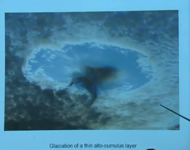
Here's a case you can see from time to time. Here's a layer of probably alto-cumulus that's liquid. Then, for some reason, and this is below the freezing point, maybe it's minus 20 Celsius. For some reason in some area that liquid has frozen spontaneously forming snowflakes and they're falling out, leaving a little clear space in the cloud, and a little plume of falling snowflakes out of that region.?